
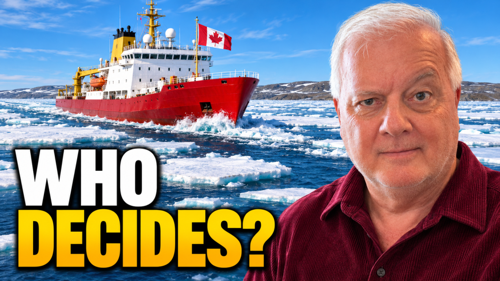
Last year, a cargo ship ran aground in the Northwest Passage and stayed there for five weeks.
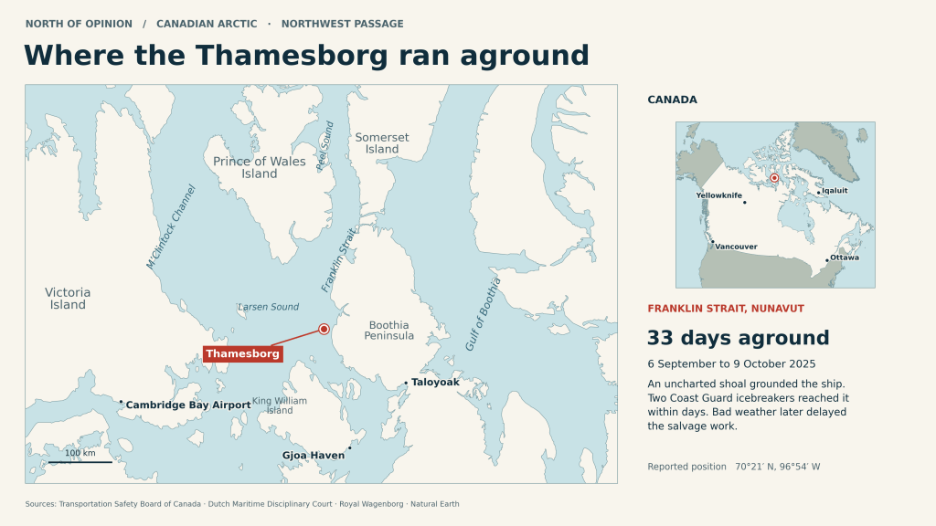
“See that red dot? That’s where the Thamesborg hit an uncharted shoal in the Northwest Passage. Two Canadian Coast Guard icebreakers reached her within days. Getting her afloat again took nearly five weeks.”
I live in Vancouver. If a ship sat aground in English Bay for five weeks, I’d have a few questions. I’ve got one about the Arctic, too. When a ship gets into trouble in waters we say are ours, how quickly can Canada get there?
That’s the question I had in mind when I looked at the November 5 federal budget. I think Ottawa is finally giving the Arctic the attention it deserves.
And, one of the best reasons to take this budget seriously is a road.
The federal government is proposing to pay the full cost of building the Mackenzie Valley Highway between Wrigley and Inuvik in the Northwest Territories.
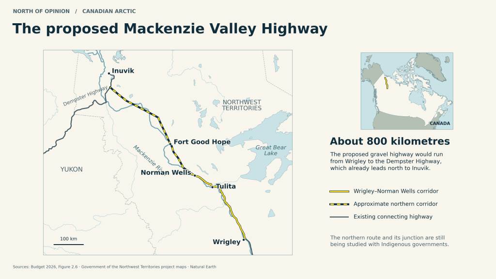
For someone in Norman Wells, that would mean a truck could bring groceries into town by road any time of year. If the community needed help in an emergency, crews could use that same road to get there. I can understand why Premier R.J. Simpson welcomed the commitment.
People have a pretty good idea what a highway would mean to them. What they need from Ottawa now is to see it built.
Farther east, in western Nunavut, an Inuit-owned company is developing a proposal for a deepwater port at Grays Bay. This one matters because of where it sits, right along the Northwest Passage. A Canadian ship working in those waters would have another place to dock. The plan includes an airstrip, with a road running 230 kilometres inland to the Northwest Territories boundary. There’s still work to do to find out whether the proposed route will work, and the plans have to go through Nunavut’s review process. Late 2029 is the target to start construction. That’s worth remembering the next time a politician mentions the port.
“Follow the yellow line from Alaska. Where it bends north through Franklin Strait, you’re back in the waters where the Thamesborg ran aground. These channels between Canada’s Arctic islands are where we disagree with Washington. Canada says they’re our internal waters. The Americans say foreign ships have a right to pass through. Even as the ice retreats, this is still a seasonal crossing.”
Some Canadian crews are already out there. In October, two Coast Guard ships completed their first security patrols under an expanded role near Cambridge Bay. Here at home, just across the harbour in North Vancouver, workers at Seaspan have laid the keel for a new Canadian polar icebreaker. We’ll have to wait until the early 2030s for that ship, but somebody is actually building it. Both of those things happened before budget day. Ottawa also announced $32 billion for upgrades to northern military bases back in March. I’ll give the government credit for getting work underway. I’ll give it credit for that $32 billion announcement once.
There’s good reason to watch what happens after the announcement. Consider the naval facility at Nanisivik in Nunavut. Canada spent just over $110 million on it. The season when the Navy could use it was short, and the dock needed expensive repairs. Meanwhile, the Navy learned its patrol ships could go farther between fuel stops than it had expected. By May, National Defence figured it would cost another $200 million to get the place fully working and decided to take it out of service. Before we build at Grays Bay, I’d like to hear who expects to use that port and how we’re going to keep it running.
Of course, a fair question is who we think we’re protecting these waters from. Global Affairs Canada considers Russia the biggest military threat in the Arctic. Its aircraft can approach North America from over the pole, and it has flown joint patrols with China near Alaska. China also sends research ships into the Arctic. The information they collect about the ocean floor can help a submarine find its way, too. Canada has signed agreements with Australia to acquire radar that can detect aircraft much farther away. That should give us more time to respond once the system is up and running.
What caught my attention, though, was what people who live in the North had to say. In this year’s Canadian Arctic Survey, 650 northern residents were asked which country they saw as the greatest threat to the region. Nearly half named the United States.
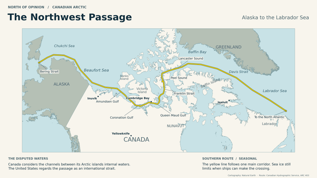
“Follow the yellow line from Alaska. Where it bends north through Franklin Strait, you’re back in the waters where the Thamesborg ran aground. These channels between Canada’s Arctic islands are where we disagree with Washington. Canada says they’re our internal waters. The Americans say foreign ships have a right to pass through. Even as the ice retreats, this is still a seasonal crossing.”
That answer makes a little more sense when you look at the disagreement we already have with Washington. Canada says the waterways between our Arctic islands are Canadian waters and we get to decide who sails through.
The Americans say the Northwest Passage is an international strait, and foreign ships have a right to pass through it. We’ve managed that disagreement for decades. Under a 1988 agreement, American icebreakers get Canada’s consent to enter the waters in question. Both countries kept their legal positions. We can defend North America together and still have a very real disagreement over who makes the rules close to home.
If we’re going to insist on making those rules, I think we owe the people who live there a say in them. Nunavut Premier John Main welcomed the defence investment. He also said his government hadn’t been consulted about where new military facilities would go. That’s quite an omission. An Inuit hunter who travels over sea ice can tell you what happens to a familiar route when an icebreaker cuts across it. I’d want that person at the table while there’s still time to move a line on a map.
Speaking of maps, here’s one figure I’d like Ottawa to pay attention to. The Canadian Hydrographic Service says less than half of our key Arctic shipping routes have been surveyed well enough to meet its standards. Ships have charts. In some places, crews still don’t have a reliable picture of what’s beneath them. Measuring the depth of those channels would be a sensible way to spend some money, especially if we expect more ships to use them.
So, did this budget go far enough? I think it gives Canada a serious start. I’m encouraged by the highway commitment, and I like the fact that Inuit are leading the proposal at Grays Bay. I’m still looking for evidence that Canada can reach a vessel in trouble throughout the Passage, whatever the season.
When that cargo ship ran aground last year, it sat there for five weeks. The next time it happens, I want the people on board to call the Canadian Coast Guard and hear, “We can get to you.” To me, that’s what it means to say these waters are ours.


Leave a Reply